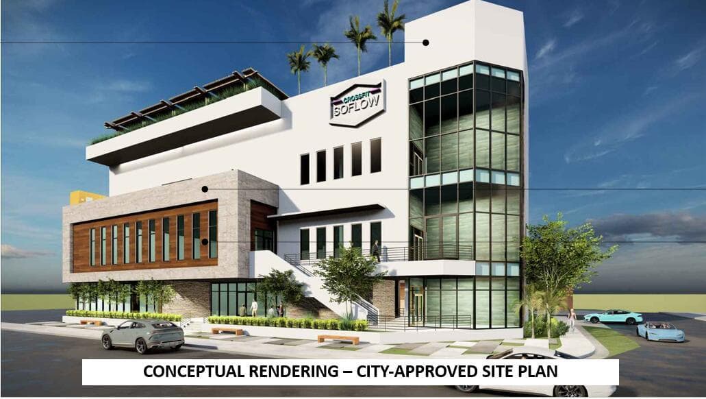
1048 E OAKLAND PARK Boulevard, Oakland Park, FL
About this property
PRIME OAKLAND PARK DEVELOPMENT OPPORTUNITY! High-visibility 18,499 SF site on E Oakland Park Blvd, west of Dixie Hwy, within the MR-Middle River District and Local Activity Center. Seller has completed substantial due diligence for a four-story commercial health/fitness and retail project that received City site-plan approval, subject to conditions and further permitting. Architectural/site plans, survey and plat materials, traffic/transportation review, engineering and geotechnical studies are available. Replat process underway through Broward County. Excellent exposure along a major east-west corridor near Wilton Manors, Downtown Oakland Park, Federal Hwy and greater Fort Lauderdale. Buyer to independently verify zoning, permitted uses, development rights and approvals. DEVELOPMENT DUE DILIGENCE PACKAGE AVAILABLE. Seller has invested significant time and resources advancing development of the property. Available materials include architectural/site plans, survey and plat materials, traffic and transportation review, geotechnical engineering investigation, civil/development documentation and City site-plan approval materials. Previous development concept contemplated a four-story commercial health/fitness and retail project with first-level parking. Geotechnical investigation included subsurface soil borings and foundation/design recommendations for the proposed development. Property is being sold as vacant land; prior plans and approvals are provided as valuable due-diligence information and are not a representation that a buyer may construct the same project without additional governmental review, satisfaction of approval conditions and permitting. Prospective buyers should independently investigate all development opportunities and requirements.
Property facts
- Location
- Oakland Park, FL 33334
- County
- Broward County
- FEMA flood zone
- Zone AE, special flood hazard area
- Base flood elevation
- 6 ft (NAVD88)
- Ground elevation
- 6.1 ft
- Hurricane evacuation zone
- Not in a designated evacuation zone
- Distance to the coast
- 1.6 mi
Sources: FEMA National Flood Hazard Layer (panel 12011C0367J, effective 2024-07-31), USGS 3DEP, Florida Division of Emergency Management, OpenStreetMap coastline. Checked 2026-10-01. Public map data looked up at this location, not a survey or an insurance quote. Confirm with an elevation certificate, the county and your insurer.
Rent roll, cap rate, zoning, tours, off-market alternatives. Leave your email and Anthony replies, usually within 1 hour.
Interested in this property?
Contact Anthony Conners at Atlantic Commercial Advisors to schedule a showing or learn more.